
Huayna Potosi
Part 1
I’m writing this from a refugio at 5200m, on the side of Huayna Potosi. It’s a peak that looks over La Paz, and at 6088m is just over the magical 6km mark. It is also said to be one of the easiest places in the world to scale a peak this high, given the headstart you get from La Paz being at 3500m. However, as my co-climber Simon (yes, it is a little confusing!) put it, its a bit like saying ‘a slow Ferrari’ – it is still high, and cold, and our attempt at the top tomorrow will involve leaving at 1am, donning crampons and ice axes and climbing for 6 hours in the dark to hopefully reach the summit at sunrise. It’s too dangerous to climb during the day as the ice and snow melts and makes it treacherous.
Yesterday we had our first practice on a glacier, which should be fairly representative of the conditions as we go up – compact snow and ice. We have these huge boots which are double-layered like the ones you’d use for skiing, and to the bottom of these you attach ice climbing crampons – jagged metal things with points sticking out in all directions to grip the ice. The ice axe itself is a strange thing to be tottering along with; I’m not sure I would normally opt for a serrated axe to steady myself when walking, but it seems to do the trick!
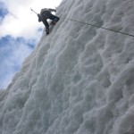
Walking on the glacier was fine with the crampons on – we learnt the techniques of keeping your whole foot against the ice so all the points dig in, and crossing your feet as you slowly make your way up the incline. We then got to the ice climbing – to say it was a tough challenge would be a massive understatement! We initially thought the guides were joking when they threw ropes over a 10m high section of ice complete with overhang. But no, with two ice axes and on a safety line, we each attempted to scale the vertical cliff, summoning energy to hurl each axe into the deep blue ice, haul yourself up on the few centimetres of purchase they appeared to have, and then kick your boots into the wall for all their worth to try to get a grip ahead of the next round. Absolutely exhausting, and we’d only climbed 5 or 10 metres! It was with some nervousness that we asked the guides how much of the ascent tomorrow would require this technique. We’ve had some different answers – somewhere between 10% (so 45 minutes) and 5 metres. I’m certainly hoping for the latter!

Practicing ice climbing - this was hard!

A long way up! That's me at the top
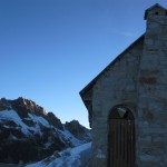
The refugio here has got fantastic views to the neighbouring peaks, emerald green lakes and the swirling clouds forming around and spiraling off the nearby mountains. It’s also consequently a bit exposed – sitting here in the early afternoon I can hear the wind howling over the roof, and without any heating, I’m still a bit cold in three pairs of trousers and three fleece layers!

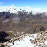
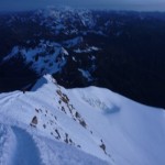
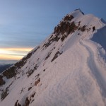
The walk to high camp
In 24 hours time it’ll all be over, we’ll have made the summit or not and hopefully be on our way back to a hot shower and warm bed back in La Paz. But for now, we’ve got a few more hours to kill (we’re going to try some high altitude frisbee!) before dinner at five and bed at six in preparation for the final part of the adventure.

High altitude frisbee!
Part 2
Well, we knew it was going to be tough!
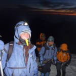
It’s pretty hard to sleep at altitude as it is, and even more so when you’re in a cold room with 20 other people squeezed onto mattresses and a howling wind tearing down the mountain making the building shake. Needless to say, we didn’t get much rest before we got up at midnight!
After a light breakfast of stale bread and jam, we donned all our layers and headed out into the darkness with crampons, an ice axe and a head torch. For safety we were roped together, the guide at the front, then me, and finally (the other) Simon at the rear. You hold the rope in one hand so you can feel when the person behind is slowing, and in the other, your ice axe as a walking stick.
The journey to the top was a long trudge on compacted snow, winding our way along a well established track up and around the mountain. The tiredness, altitude and reality combined to create some strange sights: the beautiful star-filled night sky above, and below, thousands of twinkling lights too as our head torches reflected in the snow crystals; and when you lifted your head from the monotony of watching the boots of the person in front, you could see the procession of identical triplets of lights making their way up the mountain from those in front and behind. Without any moonlight, it was the only way to get a sense of progress amid the blackness, and a sense of what steepness lay ahead. We were fortunately towards the front; we later spoke to those at the back who said that every time they looked up, the lights high above were an ominous indication of how far they still had to struggle on.
As the night wore on and we climbed higher, it got bitterly cold and even the bottles of water we had inside our coats froze solid, making dehydration an issue. We tried to eat some of the peanuts and (frozen) chocolate bars we’d brought with us but we were both feeling a bit sick from the exertion and altitude – and our bodies no doubt confused at being force-fed in the middle of the night! At one point we decided to put up our hoods as a final layer of warmth in addition to the balaclava, hat, scarf and helmet we were both wearing. The strap for my helmet wouldn’t do back up, and I spent an agonising five minutes with hands steadily going blue desperately trying to fix it, before the guide deftly sorted it out for me. Unable to feel anything in my hands and with the knowledge that we still had an hour and a half until the warmth of sunrise, I was pretty tempted to turn back, but the guide encouraged us on, and so the slog continued. We were both feeling the altitude, and the pace was slowing, but we were still moving – and faster than the other groups we passed who were pausing for breath every minute or so. I think spending the past few weeks at altitude must have done us some good!
We looked up at one point to find our first view over the surrounding peaks to the yellow lights of the metropolis La Paz and El Alto some 20km away. We could even make out the white lights of the airport runway. It was a real sense that we were getting somewhere – and we were finally walking on the high part of the mountain we had seen when leaving the city a few days before.

The lights of El Alto - you can see the airport runway in white
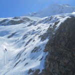
Finally, after some easyish ice climbing up a steep slope, we hit ‘polish ridge’ from where we could see the summit above us and an impossible view the other side of the ridge to the lights El Alto. I say impossible, because I couldn’t look – it was utterly terrifying. (Mum, you might want to skip this bit and go forward four paragraphs!)

That path is about a foot wide!
The ridge is named after a Polish soloist who fell to his death from here in 1994, and it wasn’t hard to tell why. On one side, a steep slope of 200m at say 60 degrees, down to snow and rocks the way we’d come up. On the other, that view to the city, a 1000m sheer drop, and a strong wind. To get to the summit, we had to edge along the ridge for 100m or so. Oh, and did I mention that this icy ridge was less than half a metre wide in places?!
Inching our way along, we didn’t get off to a good start. I had the cord on the wrong side of me, and as I tried to step over it, the guide moved off, pulling me off balance and prompting some frantic shouting on my part! After sorting things out, we set off properly and I think we both had the same thing on our minds – what to do in that quarter of a second if you feel yourself slipping or hear someone else go? The idea is that at least one of the other two people on the cord will be able to anchor themselves sufficiently to hold the weight of those dangling, but there wasn’t exactly much in which to get purchase with our ice axes, and it seemed like it would very much be luck rather than certainty. Later, Simon comically suggested that perhaps the better strategy would be for someone to throw themselves off the other side of the ridge as a counterbalance, but I’m not sure what our guide would have made of that!
We were perhaps halfway across when we realised a horrible reality – there were people coming the other way, as this was also the return route from the summit! Unfortunately for those we passed, they had to take the slightly more exposed upper of the foot-wide tracks in order to squeeze past. In normal circumstances, it might have been a time to high-five those victorious from the summit; I’m not sure our sense of balance could cope so we just exchanged weak smiles instead!
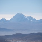
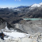
We scrambled up a snowy bank to find ourselves at last on the summit, the pre-dawn sky giving us just enough light to admire the incredible view. At 6088m, it’s the fifth highest mountain in Bolivia, and higher than any point in Europe, Africa or North America (except Mount McKinley, which is 100m higher). We were exhausted but pretty pleased with ourselves! From the top, we could see Lake Titicaca to the west, and the Cordillera Real mountain range stretching south east and below us. The mountains clearly divide Bolivia in two, with the high and dry altiplano to the west, and the humid and low amazon rainforest to the east. As if a perfect example of geography, one had low cloud stretching as far as the eye could see, and the other was barren and clear.

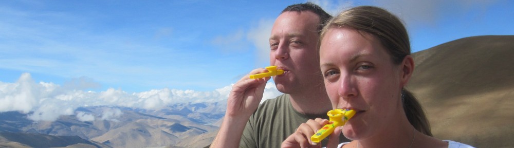
Kazoo at the summit

Simon & Simon at the summit. We're on a slope, I'm not a dwarf really!
We had brought some Scottish whiskey in a hip flask to help celebrate at the summit, but with the ridge awaiting us – and this time in a slightly more tricky downhill direction – we decided this wasn’t the time to induce even more wobbling that normal!
As you can tell by the fact you’re reading this, we made it down alive and mostly well – although I think that’s probably the first and last high mountain climbing adventure for both of us!
Simon

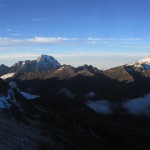
Sunrise over the mountain

The peak casting a shadow in the early morning light
-
- Huayna Potosi
-
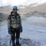
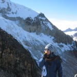
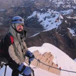
- Simon Barrow in his gear
-
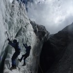
- Practicing ice climbing – this was hard!
-
- A long way up! That’s me at the top
-
- The walk to high camp
-
- The high refugio
-
- You can see the tracks we’ll be following to the summit
-
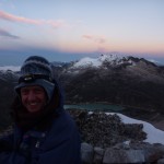
- One last kazoo before we go up!
-
- High altitude frisbee!
-
- The night before
-
- Sunset over the mountains
-
- The lights of El Alto – you can see the airport runway in white
-
- The ridge
-
- Kazoo at the summit
-
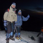
- Simon & Simon at the summit. We’re on a slope, I’m not a dwarf really!
-
- Simon before we go back down the ridge
-
- That path is about a foot wide! You can see the summit in the distance, and some other groups on the way up.
-

- Simon (Barrow) celebrating our successful ascent
-
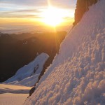
- Sunrise over the mountain
-
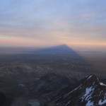
- The peak casting a shadow in the early morning light